Like this post? Help us by sharing it!
Inside Japan Tours guide Takeshi Suzuki recently spent three days hiking the Kyoto Trail with tour leader Richard Farmer. In the second of three posts on the subject, Suzuki-san describes their journey from Keage to Ginkakuji Temple.
After half a day spent exploring Fushimi Inari Shrine and the trails nearby – as detailed in my previous blog post – Richard and I set out to tackle the Mount Daimonjiyama hiking course, another section of the Kyoto Trail. This particular course commences at Keage Subway Station in Kyoto (trail board #30-2), and includes what’s known as the “Keage Incline”.
The Keage Incline was a railway line used to tow boats – the photo below shows the railway and one of the carriers used to transport the vessels. The Incline was built to aid the construction of Kyoto’s canals in the late 19th century, a massive project intended to contribute to the development of Kyoto after the capital was moved to Tokyo. Before its construction, people and horses were the only means of transportation between Kyoto and Otsu, so it was difficult to transport large loads. In addition to this benefit, the canal would provide water for irrigation, firefighting, and the country’s first hydroelectric power generator.
The Canal starts from Otsu, where Lake Biwa is located, and goes through many tunnels. From Keage, boats are lowered 35 metres using the Incline, and enter Kyoto’s city centre via the Kamo River. Today the Keage Incline is one of the most famous spots for viewing beautiful cherry blossoms in Kyoto in April.
After walking along the Incline, we moved to Sosui-daijingubashi Bridge (trail board 32), where we found the entrance to the mountain trail. From here to the top of Mount Daimonjiyama is roughly four kilometres of intermittently steep, uphill terrain. You certainly need to be fit and healthy to tackle this course – it was more like mountain climbing than hiking!
Soon after we started walking the trail, we came to Himukai Daijingu Shrine, dedicated to Amaterasu Omikami – Japan’s sun goddess. This is one of the best spots in Kyoto for leaf-viewing in the autumn.


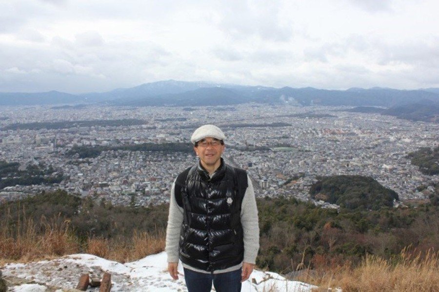
After walking through mountain forests and seeing 15 of Trail Boards, we eventually came to Mount Daimonjiyama Yotutsuji (trail board #45), and then to the top of the mountain. It took us about an hour and a half to get to this point form the beginning, and we soaked with sweat even in the subfreezing weather! But the panoramic view spread out before us was one of the highlights of this hiking trail. The sweeping view of downtown Kyoto and faraway Osaka made the difficult journey well worth the effort.


After a rest at the summit, we left the Kyoto Trail and started heading to Ginkakuji Temple via another mountain route. On the way to Ginkakuji, about fifteen minutes from the mountaintop, we reached the Daimonjiyama Fireplace. This spot is famous for its roles in the Gozan no Okuribi (Five mountains Send-off Bonfire 五山送り火), more commonly known as Daimonji Festival (大文字). This fire festival is the culmination of the Obon Festival on August 16, and sees five giant bonfires lit on the mountains surrounding the city. These fires signify the moment when the spirits of deceased family members, who are said to visit this world during Obon, are believed to be returning to the spirit world – thus the name Okuribi (送り火) which roughly translates as “send-off fire”.
From here it took us another 20 minutes or so to get to Ginkakuji Temple, where we ended our day trip. Thankfully, this downhill section of the trail was much less physically demanding. If you were to continue on the Kyoto Trail, there are various other major sightseeing spots nearby, such as Honen-in Temple, the Philosopher’s Path, Hakusasonso Gardens and Yoshida Jinja Shrine.
From the beginning to the end of our afternoon hike, it took about two and a half hours – so if you’re interested in getting a fantastic panoramic view of Kyoto (and you don’t mind the hard slog to the top!) this trail makes an excellent day trip from the city.
Watch this space for Suzuki-san’s final hiking instalment, in which he and Richard conquer yet another section of the Kyoto Trail.


